
Plan a trek in Great Himalayan National Park (GHNP). Learn about permit processes, valley routes, trail difficulties, homestays, and seasonal wildlife windows.
Introduction, Core Planning & Logistics
The Great Himalayan National Park (GHNP), located in the Kullu district of Himachal Pradesh, stands as a UNESCO World Heritage Site dedicated to protecting critical mountain species. For the independent traveler or researcher, entering this terrain requires distinct preparation. The park lacks standard tourism infrastructure inside its core zone, making it essential to understand your entry vectors, permit mandates, and seasonal weather patterns before arriving at the trailheads.
This guide details the practical logistics needed to organize a self-supported or guided trek, choose an appropriate valley route, and secure your accommodations.
Quick facts and essential takeaways
Core park parameters
The following matrix summarizes the structural details of the park to assist with early-stage trip planning.
| Parameter | Specification |
| Location | Kullu District, Himachal Pradesh, India |
| Conservation Status | UNESCO World Heritage Site & Protected Area |
| Primary Valleys | Tirthan Valley and Sainj Valley |
| Key Base Villages | Gushaini, Neuli, Shanghar, Nagini |
| Permit Office | Sai Ropa Park Office (Tirthan Valley) |
| Best Travel Windows | April to June; October to November |
| Accommodation Types | Inspection Huts (Inside); Homestays & Lodges (Outside) |
How to reach GHNP (Access & gateways)
Transit hubs to Aut
Aut is the primary transit gateway to the park valleys. Located on the Delhi-Chandigarh-Manali highway, this small town serves as the fork where travelers leave the main highway to enter the eco-zones.
- By Road: Semi-sleeper and Volvo buses running from Delhi or Chandigarh toward Manali stop at the Aut tunnel opening. The journey from Delhi takes approximately 11 to 12 hours.
- By Air: The nearest airstrip is Bhuntar Airport (Kullu-Manali Airport), situated roughly 20 kilometers north of Aut. Flights here face weather disruptions; Chandigarh International Airport remains the standard reliable alternative for long-distance arrivals.
- By Rail: Ambala Cantt and Chandigarh are the nearest broad-gauge railheads. From either station, you must catch a bus or charter a private vehicle heading toward Kullu or Manali to reach Aut.
Valley entry points and last motorable roads
Once you arrive at Aut, you must choose between the two primary valley systems that dictate your trekking route.
[Aut Junction]
|
+———–+———–+
| |
(Tirthan Valley) (Sainj Valley)
| |
[Gushaini] [Neuli]
| |
[Rolla / Shilt] [Shanghar / Maror]
- The Tirthan Valley Route: From Aut, local buses and private cabs run along the Tirthan River via Larji and Banjar to reach Gushaini. Gushaini is the definitive last motorable point for treks hitting the Tirthan axis. The drive from Aut to Gushaini takes roughly 1.5 to 2 hours over narrow mountain roads.
- The Sainj Valley Route: A separate road goes from Larji toward Neuli. Neuli serves as the primary gateway for the Sainj valley trails. A secondary mountain road climbs from Neuli toward the high meadow village of Shanghar, an alternative staging point for northern eco-zone walks.
Field Note
Mobile network coverage drops significantly past Banjar in the Tirthan Valley and past Neuli in Sainj. Always download offline topographical maps (such as OpenStreetMap data) while at Aut or before leaving your home city. Do not rely on active cellular data streams for navigation once past the entry gates.
Best seasons and climate windows
Trekking routes within the park cross wide elevation profiles, meaning trails that are clear in May are often entirely blocked by snow drifts in January.
Spring and early summer (April to June)
This window offers the most reliable conditions for multi-day alpine crossings.
- Trail Conditions: Winter snow melts below 3,500 meters by mid-April, clearing paths to major interior stations like Shilt Hut. Higher passes may hold consolidated snow sections until late May.
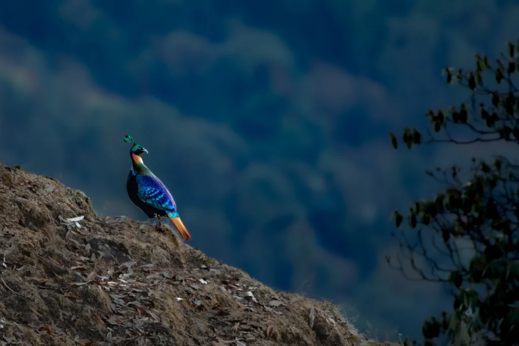
- Wildlife Visibility: This is a key period for bird species observation. Pheasants, including the Himalayan Monal, move down to the sub-alpine forest margins as fresh vegetation emerges.
- Temperatures: Daytime temperatures in the valleys range from 15°C to 25°C, while night temperatures at upper campsites like Shilt or Rangthar regularly drop to between 2°C and 7°C.
Autumn clarity (October to November)
Autumn provides dry, stable weather windows following the retreat of the southwest monsoon.
- Trail Conditions: Trails are dry, and river crossings are low and stable, which is necessary for remote routes like the Raktisar Glacier trail.
- Atmospheric Clarity: The post-monsoon air provides clear views of the high peaks, making this the preferred window for landscape and wildlife photographers who require sharp line-of-sight visibility.
- Temperatures: Temperatures drop noticeably compared to spring. Expect sub-zero night temperatures at any campsite located above 3,000 meters. Heavy insulation layers and cold-weather sleeping gear rated to -5°C are mandatory.
Monsoon risks and winter closures
- The Monsoon (July to September): The region experiences heavy rainfall, which frequently triggers landslides along the approach roads from Aut to Gushaini or Neuli. Leeches are common in the forest zones, and high river levels make remote valley walks unsafe.
- Winter (December to March): The park experiences heavy winter snow. High-altitude routes close entirely, and overnight camping inside the core zone becomes unsafe without specialized winter expedition equipment and alpine experience. Trekking during these months is generally limited to day walks in the lowest eco-zones.
Permits, Regulations & Park Rules
Entering the core protected area of the Great Himalayan National Park requires official authorization. While walking between villages in the outer eco-zone may have relaxed restrictions, any overnight stay or multi-day trek inside the park boundaries mandates a formal permit.
Where to apply (Sai Ropa), documents and timelines
The primary administrative hub for trekkers is the Sai Ropa park office, located in the Tirthan Valley. This is where all paperwork must be finalized before you reach the actual trailheads.
Follow this standard workflow to secure your entry:
- Apply at the Correct Office: All permits must be processed at the Sai Ropa park office during standard working hours. The physical entry gates into the valleys do not issue permits.
- Secure Ranger Approval: You cannot simply walk into the core zone. Your intended route must be discussed with and approved by a GHNP range officer.
- Prepare Documentation: Carry valid government-issued ID for every member of your group. Foreign nationals will face a distinct process and must present their passports and valid visas.
- Hire Local Support: For multi-day routes, engaging a trained local guide is highly recommended, and park rules often dictate local escort depending on the severity of the trail.
Practical Checklist
Because the permit process requires physical route approval from a range officer, do not plan to arrive at Sai Ropa late in the afternoon expecting to start a trek immediately. Dedicate your first morning in the valley solely to organizing logistics, meeting your local guide, and securing your paperwork.
Fees: Indians vs foreigners, group rates
The park charges a daily entry fee, meaning the cost of your permit scales directly with the length of your expedition.
The table below outlines the fee structure. Note: The figures below represent historic baselines provided by the park. Always verify the exact current rates at the Sai Ropa office prior to your arrival, as policies and pricing can change.
| Visitor Category | Daily Fee Estimate | Permit Requirement | Application Point |
| Indian Nationals | ~INR 100 / day | Required for overnight stays | Sai Ropa Park Office |
| Foreign Nationals | ~INR 500 / day | Required for overnight stays | Sai Ropa Park Office |
| Day Trekkers | Variable | Subject to distinct day-trek rules | Sai Ropa Park Office |
If you are traveling as a larger expedition, inquire directly with the park office about specific group rates and maximum party sizes. The park strictly controls the number of people allowed on high-altitude trails to minimize environmental impact and maintain conservation standards.
Route-by-route trekking guide
Selecting the right trail depends on your physical fitness, trekking experience, and the number of days you have available. The trails in the Great Himalayan National Park start at valley elevations of approximately 1,700 meters and climb into high-altitude alpine zones that can exceed 5,000 meters.
Rola to Shilt Hut (2 to 3 days)
The Rola to Shilt Hut trek is the best option if you want a short, manageable introduction to the park’s core zone without tackling extreme alpine passes.
- Logistics: The route starts from the village of Gushaini. You follow the path alongside the Tirthan River until you reach the Rola camp station, before beginning a steep uphill climb to the hut at Shilt.
- Elevation Profile: The trail starts around the lower valley level and climbs steadily to an altitude of approximately 3,100 meters at the Shilt plateau.
- Suitability: This trail is well-suited for fit beginners who are comfortable with uphill walking but do not want to navigate remote glaciated terrain.
- Wildlife Focus: The oak and bamboo forests along this trail make it a practical route for birdwatching, particularly in the spring when pheasants move down the slopes.
Rangthar to Morahani (3 to 4 days)
Choose the Rangthar to Morahani route if you want to experience expansive ridge walks and alpine meadows within a moderate four-day time window.
- Logistics: This multi-day loop takes you through the upper meadows of the eco-zone and into the steeper terrain of the Morahani ridges.
- Elevation Profile: The trail climbs out of the lower valley forest line, moving up onto exposed ridgelines that offer clear views of the surrounding valley systems.
- Suitability: This route requires good physical stamina due to continuous ridge walking and steep descents, making it best for intermediate trekkers.
Raktisar Glacier (5 to 8 days)
The Raktisar trek is designed for experienced trekkers who want to travel deep into the remote, unpopulated core sanctuary of the Sainj Valley.
- Logistics: This advanced expedition follows the path of the Sainj River up to its high-altitude glacial source.
- Elevation Profile: You will navigate a sustained wilderness route that reaches into high-altitude zones, with the upper sections of the trek ascending up to 5,800 meters.
- Suitability: This route is strictly for experienced trekkers. It demands self-sufficiency, multi-day endurance, and proper acclimatization to handle the high elevation safely.
- Trail Notes: The upper sections require walking across unstable moraine and rock scree, meaning you must plan this trek when river levels are lowest.
Parkachi-Nainda Circuit (8 to 9 days)
The Parkachi-Nainda Circuit is ideal if you are looking for a long-duration, fully isolated wilderness expedition that connects multiple high valleys.
- Logistics: This long trail crosses remote sections of the park, requiring a fully supported camping setup and an experienced local guide team.
- Elevation Profile: The loop covers varied terrain, climbing steadily through sub-alpine forests before entering high-altitude passes that reach heights up to 5,800 meters.
- Suitability: This route is recommended only for seasoned hikers and researchers who are prepared for unpredictable wilderness weather and challenging trail conditions.
Trek Route Comparison Matrix
The table below compares the core trekking routes within the park to help you match a trail to your specific schedule and experience level.
| Route Name | Duration | Peak Elevation | Difficulty Grading | Best Travel Window |
| Rola to Shilt Hut | 2–3 Days | ~3,100 meters | Moderate (Fit Beginners) | April–June / October–November |
| Rangthar to Morahani | 3–4 Days | High Ridges | Strenuous (Intermediate) | April–June / October–November |
| Raktisar Glacier | 5–8 Days | Up to 5,800 meters | Advanced (Expedition) | October–November (Dry post-monsoon) |
| Parkachi-Nainda Circuit | 8–9 Days | Up to 5,800 meters | Advanced / Remote | April–June / October–November |
Stays and staging: Inside huts vs. outside homestays
A common misconception is that you can book a standard hotel room inside the park. There are no commercial hotels inside the GHNP core zone. Accommodations are strictly divided into two distinct categories: basic wilderness shelters inside the park boundaries and community-run homestays or lodges in the surrounding eco-zone.
Inside the core zone: Inspection huts and wilderness camping
When trekking inside the protected sanctuary, your overnight options are entirely utilitarian.
- Inspection Huts: There are approximately 14 inspection huts located inside the park for trekkers to use. These structures provide a solid roof and basic shelter against mountain weather, but they have limited facilities.
- Self-Sufficiency: You cannot buy meals or rent equipment inside the core zone. You must bring all your own food, water purification tools, and sleeping supplies.
- Camping: Pitching a tent is permitted in designated areas, provided you have secured the appropriate camping permit and follow park rules.
Expert Tip
You cannot simply walk up to an inspection hut and claim a bed. You must reserve these huts through the Sai Ropa park office when you process your entry permits. Ensure you confirm availability before beginning your trek.
Outside the park: Valley homestays, lodges, and eco-cabins
The villages bordering the park boundaries act as your staging grounds before and after a trek. The Tirthan Valley is the primary hub for these accommodations.
- Primary Hubs: Villages like Gushaini and Nagini offer a wide variety of trout lodges, private cottages, and traditional homestays. Forest rest houses (FRHs) are also available outside the park boundary.
- Amenities: Unlike the park huts, these valley homestays provide fully cooked meals, comfortable bedding, and running water.
- Community Impact: Choosing to stay in locally owned homestays directly supports community-based ecotourism, ensuring that tourism revenue benefits the residents who help protect the park perimeter.
Accommodation Framework
The table below compares the realities of staying inside the core zone versus staging in the outer valleys.
| Feature | Park Inspection Huts (Inside) | Valley Homestays & FRHs (Outside) |
| Facilities | Basic shelter; very limited facilities | Beds, electricity, running water, heating |
| Food & Water | Bring all your own supplies | Home-cooked meals provided |
| Booking Method | Processed via the Sai Ropa Park Office | Booked directly with local hosts or operators in Tirthan/Jibhi |
| Primary Locations | Interior trailheads (e.g., Shilt, Rola) | Gushaini, Nagini, Neuli, Jalori Pass area |
Wildlife ecology and seasonal birding
The Great Himalayan National Park was established primarily to protect the fragile ecosystems of the western Himalayas. The variation in altitude—from 1,700 meters to over 5,800 meters—creates distinct habitats that support a wide range of protected species.
Target mammals and altitudinal tracking
Sighting mammals in GHNP requires patience and an understanding of seasonal movements.
- Key Species: The park is home to the Himalayan brown bear, musk deer, Himalayan tahr, and goral.
- High-Altitude Zones: Signs of the snow leopard are occasionally recorded in the highest, most remote sectors of the park, though actual sightings are exceedingly rare.
- Tracking Strategy: Mammals generally move to higher alpine meadows during the summer months and descend toward the sub-alpine forests when winter snows accumulate.
Western Tragopan and pheasant hotspots
For birders and wildlife photographers, GHNP is a highly specialized destination for locating elusive high-altitude pheasants.
- Target Birds: The park protects critical populations of the Himalayan monal, Western Tragopan, and koklass pheasants, alongside various raptors and high-altitude passerines.
- Observation Windows: The spring months are the best time to observe these species, as male pheasants display their breeding plumage and move through the lower oak and bamboo forests.
Wildlife Sightability Calendar
Use this general framework to plan your trek around specific wildlife observation goals.
| Species Focus | Optimal Viewing Months | Key Habitat / Behavior |
| Himalayan Monal | April to May | Sub-alpine forests; visible during spring displays |
| Musk Deer | October to November | Forest edges; easier to track when undergrowth dies back |
| Brown Bear | May to June | Upper meadows; emerging after winter hibernation |
Safety, gear, and high-altitude health
Trekking in GHNP requires serious physical preparation. The terrain is steep, and medical help is not immediately accessible inside the core zone.
Altitude acclimatization and emergency medical protocols
- Altitude Awareness: Many multi-day treks exceed 3,000 meters quickly. You must understand the symptoms of Acute Mountain Sickness (AMS) and plan itineraries that allow for proper acclimatization.
- Medical Kit: Carry a comprehensive travel medical kit tailored for backcountry travel, including first-aid essentials and any necessary personal medications.
- Evacuation: In the event of a severe emergency, immediate helicopter evacuation is rarely possible. Your local guide and trekking party are your first line of response.
- Communication: There is limited mobile network coverage inside the park. Plan for offline maps and agree on an emergency communication plan with your staging homestay or park officials before departing.
- Gear Checklist: Always pack cold-weather insulation layers and a waterproof shell, regardless of the season. Weather at high elevations changes rapidly.
Responsible travel and community ecotourism
GHNP is a protected environment. Minimizing your physical footprint ensures the valleys remain open to future trekkers.
Supporting local guide collectives and minimizing impact
- Leave No Trace: Pack out all trash, including organic waste.
- Avoid Firewood: Do not cut live wood or build unnecessary campfires, which degrade the forest ecosystem.
- Hire Locally: Engaging trained local guides and staying in community-run homestays directly supports community-based ecotourism, ensuring conservation benefits the valley residents.
Sample itineraries
The 3-day introductory wilderness trek
Route: Rola to Shilt Hut
- Day 1: Arrive at Gushaini, finalize permits at the Sai Ropa office, and hike the easy river trail to the Rola camp.
- Day 2: Ascend steeply through oak forests to the Shilt Hut at ~3,100 meters. Spend the afternoon scanning for pheasants.
- Day 3: Descend from Shilt back to Gushaini and transfer to your onward transport.
The 7-day high-altitude alpine pass expedition
Route: Raktisar Glacier Approach
- Days 1-2: Trek from the Sainj valley staging point (Neuli) through the lower eco-zone forests, establishing a steady acclimatization pace.
- Days 3-4: Climb above the treeline into the upper meadows, navigating steep moraine fields as you approach the glacier.
- Day 5: Explore the high-altitude glacial basin (up to 5,800 meters) and document the remote terrain.
- Days 6-7: Begin the long, sustained descent back to the valley floor and exit the park boundaries.
Common mistakes to avoid
- Assuming you do not need a permit: While walking around the outer valley villages is relaxed, any overnight stay or multi-day trek inside the park boundaries strictly requires a permit.
- Expecting hotels inside the park: Accommodation inside the core zone is limited to basic inspection huts or wilderness camping. All comfortable homestays and lodges are located in the outer valleys.
- Underestimating trail difficulty: Routes vary widely in elevation and remoteness. Do not attempt the Raktisar or Parkachi routes without previous high-altitude trekking experience and proper acclimatization.
Frequently Asked Questions
Is GHNP open year-round?
No. The best times to trek are April to June and October to November. The park experiences heavy snow in winter and severe rain during the monsoon.
Do I need a permit to trek inside GHNP? Yes, a permit is required for any overnight stay inside the park. Day treks may have different, slightly relaxed rules, but you should always verify with the park office.
Are guided treks mandatory?
While you must secure range officer approval for your route, hiring a local guide is highly recommended and widely available. For certain remote routes, park officials may require an escorted team.
Is angling allowed in the area?
Angling is popular in the Tirthan Valley outside the core park boundaries. You must check local rules and secure specific fishing permits from the authorities.
Are vehicles allowed inside the park?
No. The last motorable points vary by valley (e.g., Gushaini for Tirthan, Neuli for Sainj), and all travel beyond these gates requires trekking.
Resources, official contacts, and downloads
Planning a self-supported trek requires accurate, up-to-date data. Before booking your transport to Himachal Pradesh, utilize the following resources:
- Sai Ropa Park Office: Contact the official GHNP office directly to confirm current permit fees, hut availability, and document requirements.
- Navigation: Download GPX tracks and offline topographical maps for your specific route before you lose cellular service at the valley entry points.
- Preparation: Prepare a printed permit checklist and emergency contact sheet to carry in your waterproof gear bag.
By handling your logistics early, securing the right local support, and respecting the strict conservation rules, you can safely access one of the most protected alpine environments in the Himalayas.
Author Note & Update Log: Written by the WildlifeSafaris.in Editorial Team. Last Updated: August 2026.
Safari Planning : Topics Cluster
- How to book a wildlife safari in India?
- Park by Park Online Safari Booking Guide
- Tiger Safari India Planning Workbook
- Park by Park Safari Permits Guide
- National Parks Permit Guide – Park by Park Guide
- Tatkal Safari Booking Guide – Last Minute Safari Permits Booking
- Tiger Safari in India Cost
- Indian Wildlife Safari Budget Planner
- Jeep vs Canter Safari
- Best time for Tiger Sightings in India
- How far advanced should you book safari permits?
- Can foreigners book Indian Wildlife Safari online?
- Special Permits Guide for Foreigners and Domestic Visitors
- How to book a Safari Permit online in India? 2026 step by step guide
- Senior Citizens Friendly Safari Planning
- Multi Generation Family Safari Planning
- 50 things to know before your first safari in India
Himalayas : Topics Cluster
- Himalayan Wildlife Comprehensive Guide
- Wildlife in Ladakh
- Himalayan Pheasants
- Raptors of Himalayas
- Wildlife in Sikkim
- Wildlife in Arunachal Pradesh
- Wildlife in Uttarakhand
- Wildlife in Himachal Pradesh
- Wildlife in Jammu and Kashmir
- Himalayan Black Bear
- Snow Leopard
- Kibber Wildlife Sanctuary Guide
- Great Himalayan National Park
- Khangchendzonga National Park
- Eastern Himalayas